We continue the series on walking Buffalo, from the intrepid couple who walked every day—no matter the weather—in the first 30 months of Covid. They think (without being systematic) they walked every street in Buffalo, and many in other cities and towns, taking some 20,000 photos, some of which are shared in this series. While not itineraries, we hope to encourage others to “walk the walk,” to see, observe and appreciate Buffalo—and beyond. William Graebner and Dianne Bennett are also 5 Cent Cine’s film critics, here.
One can’t walk the streets—of Buffalo, or its suburbs, or its outlying towns—without noticing the ways in which Western New Yorkers define and present themselves and characterize the places they live. Visual markers—signs, murals, seals, symbols and the like—capture, and even shape, the identity of a neighborhood, a place, a street, a town or city.
Today’s photo-essay: Marking and Defining the Town, the ‘Hood, and “Place”
As measured by these markers, several of Buffalo’s neighborhoods have an especially strong sense of identity. Of these, most, but not all, are closely linked to the waterfront, which for more than a century was central to the city’s economic development.
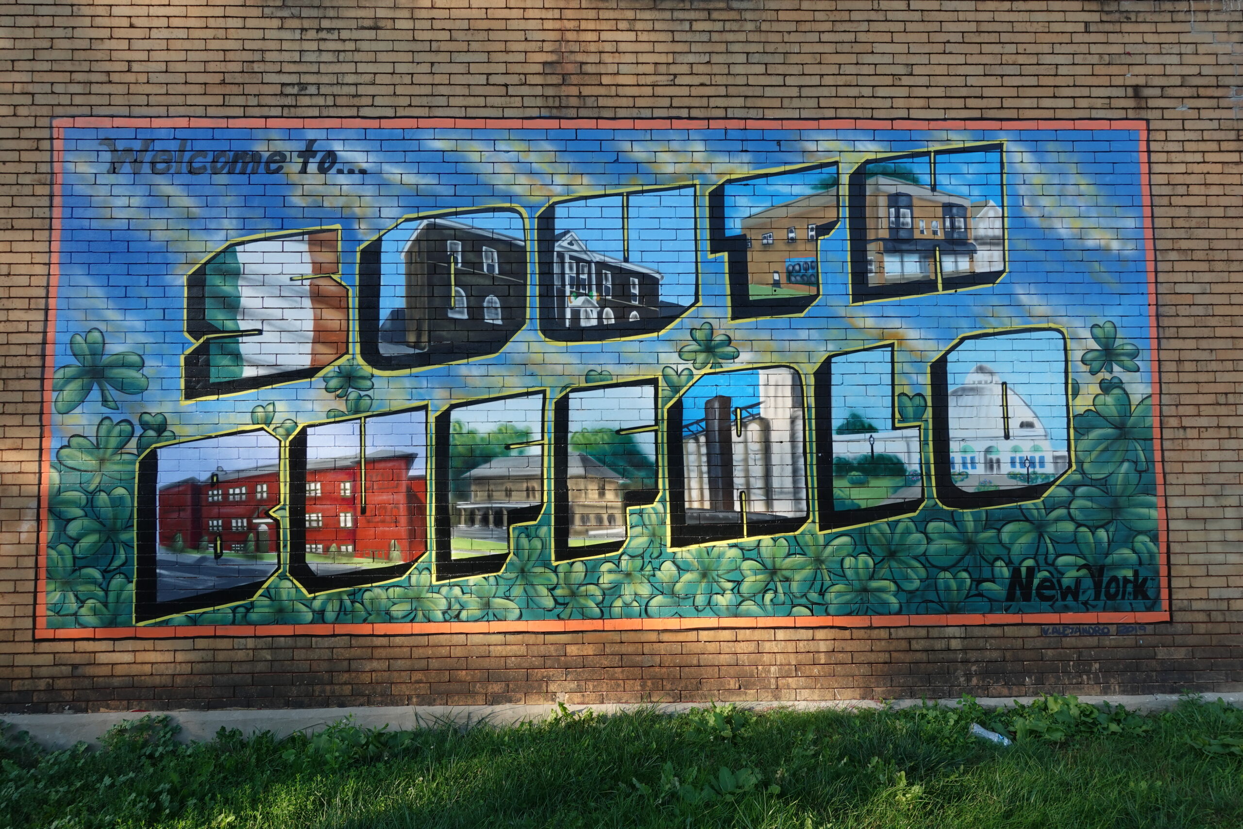
South Buffalo is among the neighborhoods with a “postcard” mural, one of several in the city painted by Buffalo artist Vinny Alejandro. It features the grain elevators, the botanical gardens, the flag of Ireland, two buildings I don’t recognize and, cleverly, the building on which the postcard mural is displayed (top right in the photo). A nearby Seneca Street yard sign celebrates the neighborhood.
The First Ward also has a wall-size welcome to the area, with old-fashioned lettering—Old First Ward—and a smattering of shamrocks. It was sponsored by Cellino Plumbing (as were murals in Kaisertown and on Hertel Avenue—note the Cellino logo, lower right) and, like the South Buffalo postcard, was accomplished by Vinny Alejandro. To the south of Republic Street there’s an endangered mural of the scoopers who risked their lives in the dust of the grain elevators. To the east at the southern end of Smith Street (on the border between the First Ward and Valley), up against Red Jacket Riverfront Park, now-defaced murals painted on the supports of railroad bridges (long removed) record the area’s waterfront-related history. Several homes in the area signal allegiance to the neighborhood with a First Ward symbol (a 1st and a W). A more informal mural, on the side of Master Market on Louisiana Street, includes the Cargill elevator.
Black Rock also identifies with the water, although that neighborhood’s history predates the grain trade—and the mid-19th-century Irish influx—that shaped the First Ward and South Buffalo. A long mural (on Amherst Street as it turns north into Tonawanda Street) celebrates the community’s link with the Erie Canal (including New York’s governor, Dewitt Clinton; the Black Rock canal that was built during his term; businesses along the canal, including a chandlery, specializing in boat supplies); the war of 1812; and the railroad bridge linking the area to Canada (still in operation). Black Rock’s relationship with the water continues to the present day, with paintings of the scholastic rowing crews (mostly Canisius High School) on the side of the Black Rock canal. A “Welcome to Black Rock” mural/gate appears to be a private initiative, set back on a driveway between buildings.
On the city’s far East Side, Lovejoy (also known as Iron Island), has a strong sense of itself, one forged by the railroad tracks that bind the neighborhood on the south and north, and at one time separated it from Sloan to the east. But (to my knowledge) the neighborhood has no mural or “postcard” to express that identity, only a sign (with a steam locomotive) and, in some years, a participatory holiday display (that includes a decorative train). An unadorned, rather forlorn sign serves as an entry point to commercial “Lovejoy Village.”
Kaisertown has a post-card-like mural (2018), another by Alejandro, a resident of the community. This one’s in a modernist mode, the period emphasized by 2 pink flamingoes, a yard motif that dates to 1957. Oddly, the mural makes no reference to any characteristic of the community, aside from its German heritage. But hold on. The name “Kaisertown” may be linked to the Poles who arrived later, specifically to the Polish name for St. Casimir’s, the splendid church in the area: Kazimierzowo.
“Valley” (a reference to the valley of the Buffalo River), an industrial area with a smattering of homes to the east of the First Ward, comes off poignantly with its aging “Promise Valley” sign, suggesting a promise unfulfilled. The Fruit Belt has a new sign, but it does little to characterize the neighborhood, which seems to cohere primarily in its street names, although its future would seem irrevocably tied to the next-door medical corridor. The sign for Old Town, a comfortable Tonawanda neighborhood whose name belies its location just to the south of the Chevy engine plant, is oriented to the factory, rather than the community.
Like Old Town, the image of the City of Lackawanna is deeply tied to industry (especially Bethlehem Steel), as well as to transportation (the railroads). Neither tie has found expression in a mural, a “postcard,” or an especially revealing sign. The entrance to Bethlehem Park, a lovely neighborhood within Lackawanna and across from where the mill and furnaces used to be, features a bust of Christopher Columbus (was the mill staffed with Italians?) and a “Welcome to Bethlehem Park” sign that links the neighborhood with the motifs of the official seal of Lackawanna: the steamboat and the sailing ship, the steel mill, and the Native Americans who once lived there. To the east, on the other side of at least a dozen railroad tracks, Lackawanna’s street signs—each naming a short street dead-ending on a rail line—reveal a neighborhood influenced by the trans-shipment of a variety of natural building products: Sand Street, Clay Street, Gravel Place. There’s even a Muck Street.
The Village of Kenmore seems determined to avoid anything that might identify it as other than a peaceful, safe suburb. Its police department has a “patch,” but the Village has no seal. If it did, it would surely include the most iconic structure within its borders, the almost 100-year-old water tower. Structurally sound, and a perfect vehicle on which to advertise whatever Kenmore has to offer, it’s about to be demolished.
With all due respect, we’ll pass on Elmwood Village (too close to home), and on the well-watered confluence of the City of Tonawanda/City of North Tonawanda, a favorite area of ours and one well served by historical markers though not, as far as we know, by a mural or postcard. Vinny, get to work!
We’ll also pass on Niagara Falls proper, which has two wall-size postcards and doesn’t need any. So powerful is the idea of Niagara Falls it can easily take over a neighborhood’s effort to see itself as a separate entity, as it does in the case of a mural intended to define the intersection of Centre and Highland Avenues; while some images are site-specific, others are straight out of the Falls playbook.
However, at least two Niagara Falls neighborhoods insist on a sense of “place” distinct from the mother city. One is Echota (Cherokee for “Town of Refuge”), a planned community of worker residences to the east of Gill Creek, designed by renowned architect Stanford White and established in 1895. The other, La Salle, was once an independent village, but since 1927 it has been a part of Niagara Falls. Even so, it exists in relative isolation (cut off by the 190 on the west and the La Salle Expressway on the north), allowing for an ongoing feeling of separateness.
Still another city indebted to water, Lockport, does indeed have a city mural, and a comprehensive one at that, created in 2015 by Bruce Adams and Augustina Droze. Although, as expected, the Erie Canal is at the center of the 2015 work, the mural also presents the region’s agricultural economy—pumpkins, apples and grapes, as well as the figure of a farmer. And it has room for three women: the “Guardian of the Water,” according to one title we’ve seen; a Victorian-era lady who may represent the suffrage movement; and, in a citation to contemporary recreational tourism (and late-19th-century feminism), a woman riding a bicycle. A series of line drawings, of gears, a valve, a pump and the like, suggests the engineering prowess that made the canal possible (and brings to mind the mural’s other title: “The Flight of Five Locks”).
Streets, too, can have an identity, or seek it. Parkside’s Crescent Avenue has adopted as its symbol (duh) the crescent! Just last year, the East Side’s Doat Street called attention to the thoroughfare in a simple but effective way: a mural with DOAT in capital letters.
The “Urban Farm” piece on Wilson Street is more billboard than mural, but it captures the street and its history. In the pre-automobile era, the street functioned as an alley for Fillmore Avenue (one block to the east), its east side, especially, lined with horse barns, some of which still exist. After 1960, with the neighborhood’s decline, great patches of Wilson Street returned to grass and fields. The billboard, and the urban farm it advertises, reflect the neighborhood’s history and present, labeling the area “Wilson St.,” “Where the Farm Meets the Sidewalk.”
Dart Street on the West Side is the site of what is likely the area’s longest mural, and, like the Wilson Street billboard, it’s about the area’s history. A genuine community effort by the Bradley/Dart/Danforth Streets neighborhood block club, some of its sections, probably painted by the area’s children, deal with love, nature and “respect,” while others are commemorative. The wall appears to be all that’s left of what was the 12-acre site of Westwood Squibb Pharmaceuticals, which once employed some 650 workers at the facility before it closed in 1996. The prominence of the company’s name on the mural suggests that the company may have funded the project, while testifying to the importance of Westwood Squibb to area residents.
Seneca Street has its own wall-size mural, situated on a particularly “vibrant” section of the street, and just steps away from the Shea’s Seneca Theater (still there, at Cazenovia Street), featured on the mural. A horse-drawn grocery wagon (AW Bartlett’s Cash Grocery) references the neighborhood’s distant past.
The street art capitol of Buffalo, Hertel Avenue has the distinction of being a street, an extended neighborhood, and a destination. It has two welcoming murals. On the west end, at Delaware Avenue, a 2021 piece by the artist Cherry sets Hertel in the context of Buffalo’s skyline, but it does not define the street. To its left, a separate piece celebrates Joey Giambra, the jazz trumpeter, songwriter, actor, and on-the-beat cop who was an iconic figure in Buffalo and, in later life, a restaurateur on Hertel Avenue.
The other welcoming mural, on the east end of Hertel at Vorhees, sponsored by Cellino and the work of Alejandro (2019), is the classic postcard (though with a modernist background akin to the Kaisertown mural). It refers to St. Margaret Roman Catholic Church (the H), the street’s restaurants, bars and businesses (both E’s), Hertel’s links to the Italian community (R and L) and the North Park Theater (the T).
One of the virtues of walking, rather than driving, is that it offers one a second chance to understand and appreciate what one sees. We had been by the mural at Grant and Amherst Streets many times, but not until a few days ago did we see it as more than an elegant tree. It is that, but the tree is rooted here in—voila′—black rock, an outcropping of black limestone along the Niagara River, the very stuff from which the area takes its name. Conveniently, the mural has the label, “Black Rock.”
How to Take a Walk in Buffalo – Look Up! Roofs and Roofers
How to Take a Walk in Buffalo – Buffalo’s Mini-Marts
How to Take a Walk in Buffalo – Remembering 9/11
How to Take a Walk in Buffalo – Street Humor
How to Take a Walk in Buffalo – The Yard as Spectacle
How to Take a Walk in Buffalo – Beware of (the) Dog
How to Take a Walk in Buffalo — Halloween
How to Take a Walk in Buffalo: Little-Known Trails and Paths
How to Take a Walk in Buffalo: Church Board Advice
How to Take a Walk—in Buffalo: Coping with Covid
How to Take a Walk—in Buffalo: Planters
How to Take a Walk—in Buffalo: Christmas Tidings
How to Take a Walk—in Buffalo: Murals… Off-the-Beaten Path
How to Take a Walk—in Buffalo: Scajaquada Creek
How to Take a Walk in Buffalo – Block Clubs
How to Take a Walk—in Buffalo – Black Lives Matter
How to Take a Walk—in Buffalo: Once a Bar
How to Take a Walk—in Buffalo: Queen City Sculpture
How to Take a Walk—in Buffalo: Flying the Flag – Education 101
© William Graebner
The post How to Take a Walk—in Buffalo, and Beyond: <strong>Marking and Defining the Town, the ‘Hood, and “Place”</strong> appeared first on Buffalo Rising.


